.jpg) |
| Gold is now available at Amazon. |
Revised 2/19/2022. Over three decades of research and exploration from 1977 to 2007, hundreds of gold anomalies and a previously unrecognized gold district were identified in Wyoming. Essentially, all of this information is discussed and described in a 365-page book entitled, Gold: Field Guide for Prospectors & Geologists (Wyoming & Adjacent Areas) available at Amazon. The book is rated 5 stars and will tell you about the geology and mining history of hundreds of gold prospects, mines and anomalies.
GOLD PRODUCTION IN WYOMING
Available production records for metals for Wyoming are far from accurate. In the past, few records were archived and production from the Wyoming
territory was often incorporated into totals of neighboring
territories, states and mining districts. However,
based on the scattered reports, it appears that sufficient quantities of metals
were recovered from Wyoming during past years to warrant further exploration in the State (Table 1). In fact, geological evidence for major gold and base metal deposits suggest there are likely several undiscovered and/or undeveloped deposits in Wyoming.
Table 1. Historic production of
selected metals for Wyoming (from Hausel, 1989a)
 |
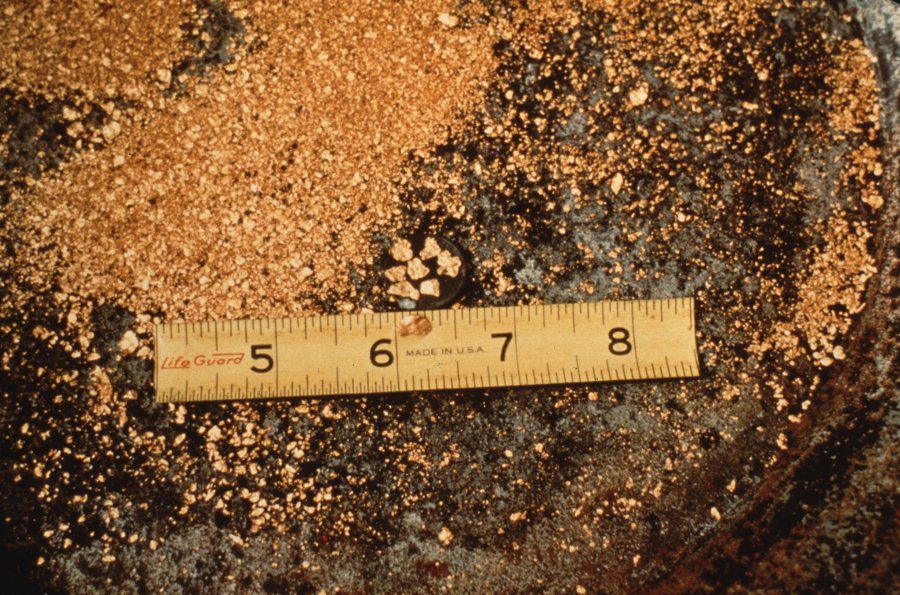
| A 7.5-ounce nugget found by a metal detectorist at South Pass |
Based on the reported production for Wyoming, compared to the surrounding regions (Colorado, Utah, Idaho, South Dakota, Montana) it is apparent that Wyoming has greatly underproduced compared to the adjacent states suggesting that some major gold deposits remain to be found (Hausel and Hausel, 2011). Metal deposits are scattered
throughout the stratigraphic record in Wyoming; however, the greatest
concentrations are found in rocks of Precambrian and Tertiary age. The very ancient Archean (>2.5 Ga = more than 2.5 years old) rocks have a number of
significant metal and semi-precious stone deposits and anomalies. These rocks are folded
and metamorphosed sedimentary, volcanic, and plutonic rocks exposed in the core of mountain ranges. Keep in mind that folds are very important in focusing gold deposits in places like South Pass.
Archean rocks of interest include sheared rock, quartz veins, along with nearby banded iron formation, massive hematite, localized veinlet and disseminated
scheelite, vein nephrite (jade), ruby and sapphire schist, podiform and
veinlet chromite, metagraywacke and amphibolite. Granitic rocks
include copper deposits, some rare earth deposits (REE), tantalite, and beryl pegmatites. Rare aquamarine beryl and green tourmaline
have been reported in some pegmatites. In addition, some of the largest colored gemstone deposits in the world were discovered in metapelite near the Elmers Rock Greenstone belt. These deposits are mostly iolite (some gems my thousands of carats in weight) found in quartzofeldspathic gneiss adjacent to sillimanite gneiss, kyanite schist and ruby- and sapphire-vermiculite schist.
 |
| Mineralized terranes and districts in Wyoming (after Hausel, 1997). |
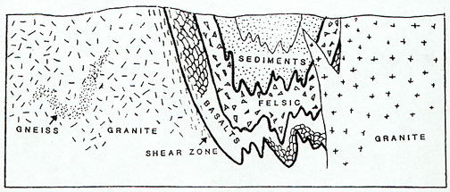
In southeastern Wyoming, thick
Proterozoic (<2.5 Ga) metasedimentary rock successions crop out as
miogeosynclinal wedges unconformably lying on top of the Archean basement. These include quartzite-hosted Cu-Ag-Au (copper-silver-gold) deposits, Au-Ag veins, and radioactive Witwatersrand-type metaconglomerates (metamorphosed conglomerates) with isolated Au anomalies and a few diamonds. This miogeoclinal
terrane is separated from a predominantly metavolcanic terrane to
the south by a major Precambrian suture, or shear zone, known as the Mullen Creek-Nash Fork shear zone. The suture includes scattered Cu-Au-Ag and
some Pt-Pd (platinum-palladium) bearing cataclastics. In fact, the first deposit commercially mined for palladium and platinum (with value-added copper, gold and silver) in north America was the New Rambler mine in the Medicine Bow Mountains. This mine was located along a shear zone at the edge of a layered mafic complex suggesting there is likely a cumulate (lode) source for the platinum and palladium along with vanadium, titanium and chromium in this area in what is known as the Mullen Creek and Lake Owen layered mafic complexes. But these areas were strategically withdrawn by the US Forest Service.
.JPG) |
Gold in black sands from Douglas Creek placer district, Medicine Bow
Mountains, Wyoming. |
South of the suture, a Proterozoic
metavolcanic terrane (1.8 to 1.6 billion years old) includes volcanogenic (derived from volcanic activity) Zn-Cu-Ag (zinc-copper-silver) massive
sulfide deposits similar to the massive sulfides at the United Verde Mine in Jerome, at least one Cu-Au porphyry, and two large layered mafic
complexes (1.8 billion years old). The northern edge of one of these intrusives yielded some
Pt and Pd with Cu, Au, and Ag at the beginning of the 20th century. A 350 mi2 anorthosite batholith (1.4-1.5 billion years old) in the
Laramie Mountains has long been considered as a possible source of low-grade
aluminum ore as well as extensive disseminated and massive Ti-Fe-V (titanium-iron-vanadium) deposits. At one point along the margin
of the batholith is a Cu-Au-Ag-W-Mo (copper-gold-silver-tungsten-molybdenum) lode with anomalous nickel (Ni). And in this area may be one the largest colored gemstone deposit found on earth, the Sherman Mountains iolite deposit that was briefly investigated by Wyoming Geological Survey geologist Dan Hausel and suggested it could potentially host more than a trillion carats of iolite gems based on past cordierite resource investigation in 1949. In addition to these gems, large resources of spectrolite (labradorite) are found and some kimberlites intrude the anorthosite near Grant Creek suggesting a possibility for diamonds and other gemstones.
.JPG) |
| A close look at this small nugget from Douglas Creek shows it is rounded suggesting that it traveled some district from its source. |
Mineralizing events for much of the
Phanerozoic (rocks from about 541 million years old to the present) was not widespread, although there were several spatial events in various parts of the State. Phanerozoic rocks can be separated into the Paleozoic, Mesozoic and Cenozoic. Within Paleozoic rocks (those deposited 541 to 252 million years ago), Au-REE (gold-rare earth elements) anomalies are described in Cambrian conglomerates, diamonds are found in some Cambrian- and Devonian-age kimberlites at Iron Mountain in the Laramie Range and in the Colorado-Wyoming State Line district south of Laramie. Another diamond-bearing kimberlite was described at Grassrange, Montana (Tertiary age) and possibly in one of the kimberlites in Riley County Kansas (Cretaceous age). These are surrounded by hundreds of cryptovolcanic structures of unknown origin that need to be prospected. While consulting for Echo Bay, Dan Hausel highly recommended the company consider the Grassrange intrusives as diamond prospects prior to discovery of diamonds at the Homestead kimberlite at Grassrange.
(GemHunter.webs.com).JPG) |
Early Jurassic prospectors searching for gold (colored pencil
sketch by the author). Original sketch donated to the
University of Wyoming Geology Museum. |
There are several Pennsylvanian and Mississippian Cu-Ag and Mn (manganese) carbonate-hosted occurrences in Wyoming that appear to have limited extent. Permian phosphatic shales and black shales are reported to contain a
number of unusual metal anomalies in western Wyoming. Ag-Cu-Zn (silver-copper-zinc) stratabound
deposits are found in bleached Jurassic redbeds in western Wyoming, and the
broad Wyoming basins include some enigmatic gold occurrences and anomalies that
can only partially be explained by detrital transport in fluvial systems. Rocks of Late Cretaceous age along the flanks
of some uplifts have scattered black titaniferous sandstone deposits that represent ancient beach deposits. These include detrital heavy minerals with anomalous Ti (titanium),
Zr (zirconium), REE (rare earth elements), and in some cases Au (gold).
 |
Folded schist in the Medicine Bow Mountains of Wyoming.
Note that these rocks provide evidence of two episodes of
folding. The primary folds are isoclinal folds in that the fold
limbs are parallel and indicated intense folding. |
Tertiary rocks host important
ore deposits, occurrences, and anomalies. These also provide examples of extreme global warming with widespread swamps depositing giant resources of coal, particularly in the Powder River Basin. It is interesting this (and many other climate change events) was a natural event and like all previous global warming events, the planet naturally recovered. Some events were possibly due to increased volcanism, impacts, mountain building, plate tectonic movements and sunspot activity.
Some of the largest ore deposits and areas of mineralization in the
state are associated with the Cu-Ag porphyries in the Absaroka Mountains of northwestern Wyoming. These are similar to the great copper-porphyry deposits in Arizona, Butte Montana, Santa Rita New Mexico, and Bingham Utah. This deeply incised
volcanic plateau includes several Tertiary age composite stocks with zoned
hydrothermal alteration and mineralization. Usually thought of as copper deposits, such porphyries contain significant Cu (copper), Ag (silver), Pb (lead), Zn (zinc), Au (gold), Ti (titanium), Mo (molybdenum) and sometimes REE (rare earth elements). But ALL of these giant deposits were piecemeal withdrawn from exploration and mining by the US Forest Service. To the north of this region, the Crown Butte gold mine in the New World district, was located on private property but was forced to terminate development during the Clinton Administration likely in response to UN agenda 21. There was no evidence that any mining activity would have affected Yellowstone National Park, as the mine was northeast of the park. Yellowstone is a caldera and provides one of the most caustic environments on the surface of the earth.
In the Black Hills of northeastern
Wyoming, Au-Th-REE (gold-thorium-rare earth elements) mineralization and large fluorite deposits are associated with Tertiary alkalic
intrusives. In addition, some Pb-Zn-Ag replacement mineralization and Sn (tin) pegmatites are found in this region. Significant gold and silver, in particular, we detected by Hausel (1997) at Mineral Hill in this area. The Rattlesnake Hills in central Wyoming were intruded by similar Tertiary
igneous rocks that intrude an Archean greenstone belt, implying this terrain to have the high potential for gold deposits similar to Cripple Creek. Gold was discovered in this area in 1981 by the author.
.jpg) |
Isoclinally folded metagabbro at the Duncan gold mine,
South Pass. Some of these folds in shear zones likely
control ore shoots as the plunge into the earth to unknown
depths to form saddle reef-type gold deposits. |
The Tertiary of Wyoming was not only
a time of volcanism, but was also an important time of paleoplacer
development. Paleoplacers are nothing more than fossilized placers where stream and river sediments were deposited in the geological past. In many cases, the original source rock for the sediments was removed over time leaving a paleoplacer high and dry with no obvious source. Most of these deposits were buried under thick overburden that sufficiently compressed and solidified the otherwise detrital sediments to produce hard rock. These hard rocks contain valuable gold (about 50% of the gold mined in the world was from paleoplacers in the Witwatersrand of South Africa), uranium and some diamonds.
.JPG) |
Consolidated gold-bearing paleoplacer with distinct, rounded
stream worn pebbles in a limonite-stained sandstone matrix. |
Laramide uplifts were
nearly leveled by erosion over time, which resulted in deposition of large volumes of fluvial
conglomerate and fanglomerate along the flanks of the uplifts. Where these conglomerates were eroded from
mineralized terranes such as greenstone belts, they often contained gold. Today most commercial placers worldwide are mined for gold, although some cassiterite, native platinum, scheelite,
monazite, diamond, chromite, tantalite and various gemstones may be recovered with the gold.
VERY OLD MINERAL DEPOSITS (Archean)
The ancient geology of Wyoming is often compared to some of the richest precious metal regions of the world
including South Africa, Western Australia, and the Superior Province of
Canada. These areas are underlain by
ancient Archean cratons with some of the oldest rocks on the surface of the
earth. But unlike these other cratons,
the Wyoming craton (termed the Wyoming Province) has been greatly modified by
Laramide tectonics, which thrust slices of the ancient craton through much younger Phanerozoic
sedimentary rocks to the earth's surface. Due to the
unfortunate nature of the Laramide tectonics, vast regions of the Wyoming
craton remain at the bottom of the Tertiary basins unavailable for direct
observation, but the exposed slices in the mountain cores contain some of the
best exposures of Archean rock in the world. And the fact that these regions have been affected by early ductile deformation and metamorphism during the Archean (2.8 Ga), later hydrothermal alteration during the late Archean (2.6 Ga), and another thermal event during the Proterozoic (2.2 Ga), and additional deformation (brittle) during the Laramie orogeny there should be plenty of structures in the greenstone belt to trap any gold that was mobilized.
 |
Stretched pebble conglomerate from the Medicine Bow
Mountains Wyoming showing white, lens-shaped quartz
pebbles compressed by more than 2 billion years of deep
burial under thick overburden. |
The Wyoming Province is not confined
to the State of Wyoming, but extends into northern Utah, extreme northeastern
Nevada, the eastern edge of Idaho, portions of Montana, and the northwestern
corner of South Dakota. And
according to Condie (1976), the Wyoming craton may have once been connected to
the Superior Province (crayon) of Canada.
Similar to other cratons of the
world, the Wyoming craton is also highly mineralized. Mineral resources include those of the Stillwater complex (platinum, palladium, chromium) in Montana, the Jardine gold district in Montana, the Homestake gold mine in South Dakota, the South Pass gold and iron ore district, the Seminoe Mountains gold and iron district, the Rattlesnake Hills gold district, the Hartville iron district, and the central Laramie Range gemstone district in Wyoming.
The Wyoming Province is formed of a
vast region of high-grade gneiss and migmatite intruded by granite and
granodiorite plutons with scattered blocks, fragments, and belts of
supracrustal terrains that include greenstone belts, eugeoclinal successions,
layered mafic complexes, and high-grade metamorphosed supracrustal belts. Mineral occurrences in the granite-gneiss
terrane are uncommon, but the supracrustal belts have hundreds of gold, base
metal, and related mineral deposits and prospects.
Greenstone Belts
Robert Houston (1983) noted that the Wyoming Province
contained supracrustal successions (layered metamorphic rock) of low-rank metamorphosed rock in the
southern part of the craton (South Pass, Rattlesnake Hills, Elmers Rock and Seminoe Mountains) that exhibited similarities to greenstone belts
in other cratons of the world. However,
in the northern region of the craton, the rank of the supracrustal belts
generally increases, and the belts are lithologically distinct in that they
are formed of intercalated amphibolite and gneiss with subordinate successions of meta-sedimentary rocks that include quartzite, metapelite, BIF (banded iron
formation), amphibolite, and minor metacarbonate. Exceptions occur, such as the Jardine belt of
the Snowy Range block of the Beartooth Mountains in the northern portion of the
Wyoming craton, which was reported by Thurston (1986) to exhibit similarities
to the South Pass greenstone belt in the Wind River Mountains in the south. But it was Houston's contention, that the
greenstone belts represented the greatest potential for mineralization
compared to any other part of the Province. These belts host several known gold deposits.
In general, the Wyoming greenstone
belts form tripartite successions of low-rank metamorphosed (upper greenschist
to middle amphibolite facies) sedimentary, volcanic, and plutonic rock, folded
into a regional synclinorium. Bedding
and most structural features (i.e., foliation, isoclinal fold axes, gold-bearing shear zones) parallel the axis of the synclinorium. Although amphibolite facies metamorphism presides in these terranes, the overall metamorphism is relatively low resulting in the preservation of some primary
textures. Pillow structures, and
porphyritic, amygdaloidal, spinifex, and cumulus textures are preserved in some
igneous rocks. Graded bedding, quartz
pebbles, cross-bedding, and cut and fill channels occur in some metasedimentary
rocks.
The lower portions of the greenstone belts are
formed of ultramafic to mafic metavolcanics that may include hornblende amphibolite (orthoamphibolite), serpentinite, tremolite-talc-chlorite schist and metabasalt. These
rocks have compositions that suggest they represent the metamorphosed remains of high-magnesian basalts and tuffs, and komatiitic basalts and peridotites. The majority of these rocks have high in magnesium and low in silica suggesting that the erupted directly from the earths upper mantle.
 |
| Pillow basalts (basalts deposited in water). |
The character of the greenstone
successions changed through time, and
the underlying successions were replaced by more calcium and iron rich calc-alkaline metavolcanics
(meta-andesite, metadacite, felsic schist), high-iron tholeiitic basalts
(amphibolite, greenstone, and metabasalt), and metakomatiite (actinolite
schist, hornblende-plagioclase amphibolite, tremolite-talc-chlorite schist, and
minor serpentinite). Metasedimentary
rocks are prominent in the upper succession and include metagreywacke, BIF,
with lesser quartzite, graphitic schist, metaconglomerate, and metapelite.
 |
Spinifex textured komatiite from the Hannas Lake
Serpentinite, Australia. |
Some greenstone belts and
fragments are recognized in Wyoming and include South Pass in the Wind River
Mountains, Barlow Gap and Tin Cup in the Granite Mountains, the Seminoe
Mountains, Casper Mountain, Sellers Mountain, Esterbrook, and Elmers Rock in
the Laramie Range, as well as other fragments in the Laramie, Medicine Bow, and
Sierra Madre ranges (Condie, 1967; Houston, 1983). South Pass greenstone belt & mining districtsThe South
Pass greenstone belt in the
southern Wind River Mountains encloses the Anderson Ridge pegmatites, the South Pass-Atlantic City district, the Miners Delight district, the Lewiston district and the Crows Nest. The northern edge of the greenstone belt is overlain by placers and Tertiary paleoplacers of McGraw Flats-Twin Creek and the southern margin of the greenstone belt projects under younger sedimentary cover and also under the Dickie Springs-Oregon Buttes placers and paleoplacers. Much of this gold area was incorporated into the Sweetwater Mining district in the 19th century.
The greenstone belt crops out over an area of roughly 250 square miles, and a large portion of the belt continues under a thin (<1 foot to > 2,000 feet thick) blanket
of Tertiary arkosic sandstone, siltstone, and conglomerate. The extension of the greenstone belt as far south as to the base of Oregon Buttes was confirmed by both drilling and aerial geophysics by Hecla Mining in the 1980s. During the past, this region received only minor exploration interest for lode, paleoplacer, and placer
gold, yet the region offers the greatest potential of all of the
greenstone belts in the Wyoming craton for discovery of significant
mineralization. Precious and base metal
deposits in the belt include auriferous
shear zones and veins, associated Tertiary paleoplacers and modern placers, restricted Ag-
and Au-bearing cupriferous veins, and cupriferous stockworks.
 |
| The South Pass greenstone belt (after Hausel, 1991). |
Shear zones in the greenstone belt
are mostly narrow, foliation-parallel, cataclastic zones, that exhibit both brittle
and ductile deformation and have strike lengths of dozens of feet to more than
11,000 feet (Hausel and Hull, 1990).
Widths are typically between 2 to 15 feet, although greater widths occur
at several mines. For the most part,
these structures are weakly mineralized along much of their trend with
localized ore shoots that may plunge to depths of more than a thousand feet. The shoots occur
at pinches, swells, fold closures, attitude changes, and at intersections of
structures.
Historic reports indicate the gold tenor
of the ore shoots ranged from a trace to as much as 3,100 opt Au. Average mine grades varied from 2.06 ppm
(0.06 opt) to 68.6 ppm (2.0 opt) Au with minor silver (Hausel, 1989a). The
continuation of these structures downdip has not been fully tested since the
deepest gold mine is only 400 feet deep, and drilling penetrated the
mineralized structures to depths of only 930 feet below the surface (deQuadros,
1989). It is likely that these shoots continue to the base of the greenstone belt (a few thousand feet or more?).
Many of the shears and veins are
localized in metagreywacke and hornblendic amphibolite with fewer in graphitic
schist, meta-andesite, greenstone, greenschist, metatonalite, and
tremolite/actinolite schist. A large
proportion of these gold-bearing structures are found along or adjacent to lithologic contacts of
rocks with contrasting competency (Bayley, 1968; Hausel, 1987), such as the metamorphosed graywackes and graphitic schist as opposed to the more competent metamorphosed gabbros (metagabbros) and basalts (amphibolites).
The source of the gold found in the shear zones was suggested by Bow (1986) to have been rocks of komatiite affinity. But
recent stable isotope and fluid inclusion studies by Spry and McGowan (1989)
are redolent of a greywacke source. Hausel (1991), however, was impressed by the ubiquitous occurrence of
structurally controlled gold anomalies throughout the greenstone belt
independent of rock type and proposed the gold was derived by metamorphic
secretion during a 2.8 billion year old regional metamorphic event, and the shears served to
focus the auriferous fluids.
In addition to narrow mineralized
structures, the possibility exists for
large-tonnage, low-grade, precious metal deposits in this greenstone belt. Four mines suggested as possible large tonnage deposits by Hausel (1991) include the Carissa,
Duncan, Lone Pine, Wolf, and Tabor Grand.
 |
| The gold-bearing Carissa shear zone hosts a major, unmined gold deposit. |
At the Carissa mine in the South
Pass-Atlantic City district along the northern flank of the greenstone belt,
the principal shear is a narrow 5 to 50 foot wide structure enveloped by a broad, 300 to 1,000 foot zone of weakly mineralized wallrock with rehealed fractures. A 1.5 foot channel sample taken across the
shear assayed 5.2 ppm (0.15 opt) Au (Hausel, 1989a), and Beeler (1908) reported
the average ore ran 10.29 ppm (0.3 opt) Au. Composite chip samples collected in the adjacent wallrock also yielded
anomalous gold over a 97 foot width (Hausel, 1989a). The mineralized structure was appears to have a with of nearly 1000 feet with considerable strike: significant gold was intercepted at depth in the deepest drill holes drilled in the area to a depth of 970 feet. Based on geology, the gold bearing ore shoot is believed to continue to much greater depth (Hausel and Hausel, 2011).
 |
General location map of the South Pass, Atlantic City, and Miners Delight mining districts
showing locations of principal mines, faults and streams (after Hausel, 1991). |
At the Duncan mine, the
foliation-parallel shear is folded and splayed. The splay has a aggregate width
of more than 40 feet adjacent to the shaft, and is mineralized across its
entire width. But within the fold
closure, the gold values are enhanced, and the nose of the steeply plunging
drag fold averages nearly ten times the amount of gold in the fold limbs.
In the Tabor Grand mine, a 1 to 5 foot
wide shear cuts hornblendic amphibolite.
Samples of the shear yielded 0.06 to 58.0 ppm Au (0.002 to 1.87 opt) over a 350 foot
length. During mapping of the
mine, a second shear parallel to the first was discovered 20 feet south of the
primary shear. Two samples taken in this
shear yielded 1.7 and 7.0 ppm Au. Surface mapping extended the length of the shear another 800 feet to the
east where an 8 ft channel sample assayed 3.8 ppm Au (Hausel, 1991).
At the Lone Pine mine in the
Lewiston district along the southeastern margin of the greenstone belt, a
hidden shear was discovered under a thin veneer of Tertiary
South Pass Formation. The discovery
trench exposed a 17-foot wide shear which yielded gold values of 0.47 to 3.5 ppm. The maximum mineralized width and strike length of this structure
have not been determined. At another
mine in the same district known as the Wolf mine, representative samples
yielded 23.3 ppm (0.68 opt) Au (Hausel, 1989a). This property was later examined by U.S. Borax, and it was determined
the shear was mineralized over a width of more than 100 feet.
_________________________________________________________________________________
Chip channel and
channel sample analyses in the South Pass greenstone belt (Hausel,1989a).
_________________________________________________________________________________
SAMPLE
DESCRIPTION
|
Au
|
Ag
|
Carissa
Mine
|
(ppm)
|
(ppm)
|
0 to 10
ft north of shear
|
0.4
|
--
|
10 to 20
ft north of shear
|
1.05
|
--
|
20 to 37
ft north of shear
|
2.5
|
--
|
0 to 10
ft south of shear
|
0.65
|
--
|
10 to 20
ft south of shear
|
0.25
|
--
|
20 to 30
ft south of shear
|
0.30
|
--
|
30 to 60
ft south of shear
|
0.35
|
--
|
30 ft
composite north of shear
|
2.4
|
--
|
Duncan
Mine
|
|
|
0 to 2
ft west of fold closure in shear
|
3.0
|
2.2
|
2 ft
channel across fold closure
|
33.0
|
6.0
|
0 to 5
ft east of closure
|
1.8
|
1.8
|
5 to 15 ft east of closure
|
6.6
|
2.7
|
15 to 25
ft east of closure
|
0.71
|
7.4
|
25 to 35
ft east of closure
|
0.53
|
1.0
|
Lone
Pine Mine
|
|
|
0 to 4
ft (E to W) in shear
|
0.47
|
2.5
|
4 to 7
ft (E to W) in shear
|
0.69
|
1.9
|
7 to 11
ft (E to W) in shear
|
3.5
|
4.3
|
11 to 17
ft (E to W) in shear
|
1.6
|
2.9
|
_________________________________________________________________________________
The Wolf mine, also located within the Lewiston district, has both good strike length and width. The depth of the structure is unknown, but there is no reason to assume it doesn't continue to a few thousand feet. Recently, Visionary Gold, a Vancouver BC company, began exploring this property at about the same time that the plandemic was perpetuated. They plan to drill and sample this search structure to find out if it has minable gold values and tonnage. In a recent press release, the company reports: "gold mineralized zones were encountered in each of the first five drill holes, confirming continuous gold mineralization over 1,536 feet of the 8,200+ foot long shear zone. Intersecting gold values in each drill-hole of the first-ever drill program in the Lewiston District confirms the existence of a large gold-bearing hydrothermal system, supporting our exploration thesis,” stated CEO Wes Adams. “We know from extensive surface sampling and mapping that higher-grade zones of mineralization exist within the Wolf Shear structure, but more drilling is needed to further define them. Additionally, we plan to drill-test three recently defined parallel mineralized structures that have been identified adjacent to the Wolf Shear Zone, as well as other new targets generated during a busy 2021 field program. Full results from regional exploration and a summary of new drill targets will be forthcoming.”  |
Generalized map of the Lewiston district, South Pass, Wyoming (after
Hausel, 1991) |
In addition to the gold-bearing shear zones (lodes),
cupriferous veins with Au and Ag values are found at some locations in the
belt. These veins have little economic
value because of the lack of tonnage. They are seldom greater than 2-feet wide and pinch and swell over short
distances along strike. However, one
Cu-Ag stockwork discovered along the northwestern flank of the belt may be of
interest. The extent of the stockwork is
unknown since it lies under soil in a large aspen grove. Grab samples of the mineralized rock yielded
3.23 % Cu, 3.2 ppm Ag, and 0.16 ppm Au (Hausel, 1991).
The South Pass belt also
has extensive iron deposits in the limbs of the South Pass synclinorium. The BIF along the northern flank of the belt
was structurally thickened fourfold by internal folding and plication and by
repetition along faults. This deposit
was reported by Bayley (1968) to have indicated reserves of 300 million tons of
30% Fe. From 1962 to 1983, U.S. Steel
Corp. mined more than 90 million tons of iron ore from this BIF. Recent mapping by Hausel (1990a), indicates
a sizable resource is available.
The possibility of gold in the iron
formation apparently was not considered during the 20 year operating lifetime
of the mine. However, samples collected
a short distance southwest in the BIF by the Wyoming Geological Survey, yielded
gold anomalies (maximum of 1.3 ppm). Other anomalies were detected in BIF along the southeastern margin of
the greenstone belt. Only a small number
of sulfide-bearing oxide facies BIF were collected by the Survey in the open
pit mine before it was flooded in 1983.
None of the samples contained detectable gold (minimum detection limit
0.02 opt).
If you would like to make your own gold discovery in this district, there are many opportunities. Connect the dots - i.e., draw lines between a groups of mines and prospects and in-between all of these will be a hidden, gold-bearing shear zone that likely has never been prospected. As an example, use Google Earth to find the Carissa Gold Mine (42°28'29.15"N; 108°47'42.65"W) and then look to the east-north east along a 250o trend (N80oE) and you will see many holes dug in a search for the Carissa Lode. In between all of these prospect pits and mines are places that have not been prospected - anyone of those localities could be hiding an overlooked ore shoot. Remember, the prospectors who searched this area before you, had no magic powers, and they overlooked many things. This is true all throughout the greenstone belt.
Now examine Willow Creek downstream from the Carissa mine. Only small patches of this gold placer were ever mined for gold such as at the tailings at 42°27'48.64"N; 108°47'9.45"W. This drainage sampled the Carissa lode and other lodes; thus the gravels are likely very rich. Try similar investigations in the Lewiston district. There are reports of several gold nuggets recovered in that area. Search for the shear zones by using published geological maps (Hausel, 1991) and then look anywhere downstream from those shears. Look for drainages with both water and without water as the dry drainages are also likely to have some coarse gold. You are going to have to do some work and research, but there is considerable gold left in the South Pass area.
Some years ago, a local prospector by the name of Gary Nunn, found some small, but very fragile gold nuggets in what is known as the Crows Nest district. This area is mostly underlain by metamorphosed greywackes, but soil and detrital rock hide large areas and there is no question, that this thin blanket covers gold veins - some which are likely to be relatively rich in gold.
.jpg) |
The Seminoe Mountains greenstone belt includes a distinct,
large altered zone surrounding gold-bearing veins at
the Penn mines. |
Seminoe
Mountains district
The Seminoe Mountains lie in south-central Wyoming.
This belt is ~2.7 Ga (billion years old), whereas South Pass is a minimum of 2.8 Ga. The Seminoe Mountains have similar rock types
as South Pass, but in different proportions (also, it is easy to predict that based on the rocks, considerable greenstone belt rocks lie under the basins to the north and south of Bradley Peak). The relative volume of metagreywacke in the Seminoe
Mountains is less than South Pass, BIF is abundant, and the belt includes a
thick section of aphyric and spinifex-textured basaltic komatiite and cumulate-textured
serpentinite and metaperidotite (Klein, 1981; Snyder and others, 1989).
.jpg) |
| Folded BIF in the Seminoe Mountains. |
Gold is concentrated in a 1/4 mile
diameter zone of altered metagabbro and
metabasalt near the western margin of the belt (Klein, 1981; Hausel,
1989b). Samples of quartz recently
collected in this region were highly anomalous and have yielded gold values as
high as 98.4 ppm (2.87 opt). BIF is also
locally anomalous in Au and Ag.
Amphibolites in the altered zone have been overprinted by chlorite,
carbonate, quartz, and sulfide alteration assemblages (Klein, 1981). The zone
is transected by narrow quartz-calcite veins and stockworks containing minor
pyrite and chalcopyrite. Ore shoots
often yield visible gold and exhibit control by folding.
The Seminoe Mountains greenstone
belt contains ubiquitous BIF. The BIF is
interlayered with metabasalt and metasediments, and is predominantly oxide
facies. Harrer (1966) outlined a 100
million ton deposit of BIF, which varied from 28% to 68.7% Fe.
Copper deposits are sporadic and appear
to be unimportant in the greenstone belt.
Some samples with anomalous Zn and Pb were detected in a shear zone near
some gold mineralization (Hausel, 1990b), and follow-up studies on this shear
is currently in progress. The Seminoe
Mountains were explored by Kerr McGee Corp. and Timberline Minerals in the
1980s. Hausel recovered a large number of G10 pyrope garnets from the northern flank of the greenstone belt near the Miracle Mile. The source of the diamond-stability pyrope garnets has not been identified, but this area may be of interest to gold prospectors. The Tertiary gravels sitting high and dry in the flats surrounding the North Platte river in what is known as the Kortes Placer, contain gold and likely have diamonds.
Rattlesnake Hills greenstone beltThe author was attracted to the Rattlesnake Hills greenstone belt because of its favorable geology, i.e., the presence of Archean-age greenstone belt rocks with above normal amounts of gold that had been intruded by a group of Tertiary alkalic volcanic and plutonic rocks, which fragmented the adjacent greenstone belt providing both heat and fractures in which to mobilize and precipitate gold enrichments. And then, there were exhalites (pyrite-bearing silicified zones and banded iron formations) - probable high-grade zones. And sure enough, we found gold in exhalites and traces of gold in greenstone breccia in 1980. This area is has considerable potential for commercial deposits, particularly near brecciated zones within the greenstone belt rocks lying adjacent to a group of Tertiary alkalic intrusives exposed at the surface, at depth, and hidden.
T
he Rattlesnake Hills supracrustal belt is in the northern Granite Mountains. Within this belt, a 500 ft long, mineralized vein (metachert), was discovered in 1981 by the author, and named the Lost Muffler prospect. Composite chip samples 3.6 ft in length were taken in the vein, and assayed 7.5 and 4.5 ppm Au (Hausel, 1989a). Exploration in this area by American Copper and Nickel Corporation (ACNC) intersected auriferous BIF and gold-bearing Tertiary alkalic igneous rock. Drill intercepts included 10 ft of 10.3 ppm Au in BIF and 250 ft of 2.1 ppm in the Tertiary volcanics. Additional sampling by the author identified anomalous gold in nearby breccias and Tertiary alkalics and drilling to depth by recent companies on these breccias intersected some very impressive gold deposits (Hausel and Hausel, 2011). Some time after activity by ACNC, Evolving Gold began exploration and identified additional targets in the Rattlesnake Hills in 2012. Recently, the area has been under investigation by GFG Resources.
Other Supracrustal Belts.
In addition to greenstone terranes,
the Wyoming Province encloses medium to high-rank metamorphosed supracrustal
belts. These belts occur in the Tobacco
Root Mountains, the Ruby and Gravelly Ranges of Montana, and the Copper
Mountain district of the Owl Creek Mountains, Wyoming. Also in Wyoming is the Hartville uplift in
the southeastern corner of the Province.
This terrane consists of relatively low-rank metamorphosed eugeoclinal
sedimentary and volcanic rocks.
Copper
Mountain district, Owl Creek Mountains
The Copper Mountain district in the eastern
Owl Creek Mountains is interpreted as a high-grade supracrustal belt (Hausel
and others, 1985). It is intensely metamorphosed and isoclinally folded such
that all primary textures have been essentially destroyed or overprinted by
foliation. Two mappable units in the belt are similar in appearance and consist
of intercalated amphibolite and quartzofeldspathic gneiss. A third unit is
formed of gneiss, amphibolite, BIF, metapelite, and quartzite.
Scattered mineral deposits in the
Copper Mountain district include stratiform scheelite, vein Cu and Au, and
REE-Ta pegmatites. One relatively
significant development (the DePass mine) lies along the eastern edge of the
district in a 50 ft wide Proterozoic mafic dike emplaced in Archean
granite. This mine was driven into the
dike and produced a minimum of 568,000 lbs of mill concentrates in the early
1900s with receipts for Cu, Au, and Ag.
The mine has more than 11,000 feet of workings.
Hartville
district
The Hartville uplift in southeastern Wyoming
has yielded more than 5 million pounds of copper and 45 million tons of iron from
Archean schists and overlying Phanerozoic rocks. Mineral deposits in the region include the
McCann Pass pyritiferous massive sulfide deposit, scattered Cu-Ag-Au-U (copper-silver-gold-uranium) unconformity deposits and several gemstone and lapidary minerals of potential interest including onyx, copper minerals, specularite, garnet and aquamarine (Hausel, 2009, 2014, Hausel and Hausel, 2011). The Silver Cliff mine in the northern portion of the uplift was initially developed for gold and
silver in the 1870s and later mined for uranium in the early and mid 1900s
(Hausel, 1989a). Mineralization at the Silver Cliff is localized in fault gouge
and along a Precambrian-Cambrian unconformity.
 |
| Onyx, Hartville uplift |
The Hartville uplift is principally
known for its massive hematite. Hematite
was mined by C.F.&I. Corporation for many decades from hematite schist
until 1981. Total recorded production
amounted to more than 45 million tons of ore with some by-product copper. The hematite is secondary in origin and
interpreted to have been derived by groundwater oxidation and enrichment of
originally ferruginous beds (Bayley and James, 1973; Snyder and others, 1989). These deposits often contain copper as well
as anomalous gold. For instance, the
Michigan mine in the central portion of the uplift encloses two hematite
pods. The northern ore body contains 75
million tons of 25% Fe, and the southern deposit contains 41 million tons of
24% Fe (Wilson, undated). The upper segment
of these deposits are copper stained and anomalous in gold (Woodfill,
1987).
Unconformity deposits also occur in
the belt. In the northern Hartville
uplift, the Silver Cliff shaft was developed on a Precambrian-Phanerozoic
unconformity and mineralized reverse fault.
Available assay reports indicate the ore contained none to 10.88 % Cu,
none to 15.04 opt Ag, 0.001 to 3.39% U3O8, and anomalous gold (Wilmarth and
Johnson, 1954). In the southern portion
of the uplift, Kerr McGee explored a copper-stained Precambrian-Paleozoic
unconformity recovering samples with cerargyrite, unmangite, electrum, and
native gold (Kerr McGee Corp., 1988).
.jpg) |
| Malachite in specularite, Hartville uplift, Wyoming |
South of the Silver Cliff mine, a
contact between hanging wall dolomite and footwall schist is mineralized over a
1 to 15 ft thickness. Lenses from the
Copper Belt Group assayed 2 to 8 % Cu and the adjacent altered iron-stained
schist contained 0.05 to 0.58 opt Au and 2 to 5 opt Ag (Ball, 1907).
In the southern portion of the
uplift, an extensive gossan at "gossan hill" along the McCann Pass
fault was prospected by Mine Finders in the 1970s, and more recently by Exxon
Minerals. Outcrop and shallow drill
holes recovered samples with elevated Cu, As, and Zn. Deeper drilling intersected thick zones of
anomalous mineralization including 10 ft of 0.8% Zn, and 2 ft of 1.2 % Zn and
0.08 opt Au (Woodfill, 1987).
OLD, BUT NOT QUITE AS OLD OF MINERAL DEPOSITS (PROTEROZOIC AGE MINERALIZATION)
Nearly all of the Proterozoic rocks in
Wyoming are restricted to the southeastern corner of the state in the Laramie,
Medicine Bow, and Sierra Madre Mountains. The Sierra Madre and Medicine Bow Mountains are bisected by a prominent
Precambrian suture known as the Mullen Creek-Nash Fork shear zone. This shear
is projected into the Laramie Range where it is intruded by a 350 mi2 anorthosite batholith. To the south of the suture are volcanogenic
schists and metasediments of the Green Mountain terrane that represent a
Proterozoic island arc accreted to the craton nearly 1.7 Ga ago. Archean
basement rocks are absent from this region, thus the oldest basement rocks in this area are Proterozoic in age (2.5 billion to 600 million years old). To the north, however, Proterozoic miogeosynclinal metasedimentary rocks
form a thick wedge lying on the Archean basement. The Proterozoic rocks of the Green Mountain Terrane are similar to those found in the Jerome district of Arizona. These enclose several volcanogenic massive sulfide deposits rich in copper, zinc, lead, silver and gold; layered mafic complexes and ultramafic massifs containing platinum, nickel, palladium, gold, silver, titanium, chromium and copper; copper-gold-silver veins, gold veins, copper-gold shear zones, copper-REE pegmatites, gold and diamond placers and more. However, the region was piecemeal withdrawn one deposit after another by the US Forest Service making the once area of multiple use into limited and very restricted use.
Green
Mountain Terrane
Precious and base metals south of the shear
zone occur in quartz veins, massive sulfides, a porphyry, and in layered mafic
intrusions. In the Keystone district of
the Medicine Bow Mountains, N60°W-trending shears are loci for narrow veins.
These veins are gold- and copper-bearing, pyritic, quartz-carbonate veins in
tensional faults subsidiary to the Mullen Creek-Nash Fork shear zone (Currey,
1965). Mineralization is accompanied by silicification in the form of small,
irregular quartz veinlets and the wallrock is enriched in epidote.
At the Keystone mine, gold was found
in quartz, and in pyrite and pyrrhotite masses in mylonite selvages adjacent to
the vein. The vein lies in sheared diabase that intrudes quartz-biotite gneiss
country rock (Currey, 1965). The shear is 2 to 6 feet wide, locally splays to 300
feet, and continues 4,500 feet to the southeast to the Florence mine. Available information indicates the Keystone
ore averaged 41 ppm Au. When the mine
ceased operations in 1893, 100,000 tons of reserves were reported in site. Eight samples collected from the mine dump by
Loucks (1976) yielded 6.5 ppm to 300 ppm (0.19 to 8.75 opt) Au and averaged 117
ppm (3.41 opt) Au.
At the the southeastern end of the
Keystone trend, the Florence mine was developed in quartz diorite. The ore occurred as 'kidneys' of auriferous
pyrite which assayed from 257 ppm to 1,656 ppm (7.5 to 48 opt) Au (Currey,
1965). Samples collected from the mine
dump by Loucks (1976) yielded values ranging from 2.06 ppm to 799 ppm (0.06 to
23.3 opt) Au. One sample collected by
the author in 1990, consisted of limonite boxwork after pyrite with abundant
visible gold. Both the Florence and
Keystone patented claims are currently for sale, and were recently examined by
Homestake.
Volcanogenic massive sulfide
deposits occur in the Green Mountain Formation of the southern Sierra
Madre. This unit consists of relatively
low-grade metamorphosed calc-alkaline metavolcanics and associated
metasedimentary rocks and volcaniclastics. The massive sulfides are copper or zinc dominated with silver and traces
of gold. Between 1979 and 1982, Conoco
Minerals explored this region for massive sulfides. Mineralized exhalites
were discovered in metarhyolite and meta-andesite, and colloform-textured,
pyrite-chalcopyrite was associated with volcaniclastics (mill rock)
(Hausel, 1986). BHP-Utah
International is exploring to the south in Colorado for Ag-Zn. But true to nature, the US Forest Service followed all of the massive sulfide discoveries with massive withdrawals of land to limit any mining. They effectively closed all legal discoveries with their questionable tactics. One of the greatest known massive sulfides in the area is the Ferris-Haggarty mine which has a significant, unmined copper deposit with associated silver and gold. Exxon Minerals identified a large gold resource in part of the historic mine.
Silver Crown DistrictA
t least one deposit in the Laramie
Range south of the shear zone has been classified as a Au-Cu porphyry. The Copper King mine in the Silver Crown
district west of Cheyenne (Klein, 1974), was developed in weakly foliated and
hydrothermally altered quartz monzonite and granodiorite. A shaft sunk in a potassium-silicate altered
zone is surrounded by propylitically altered rock. In my opinion, Dr. Terry Klein is a brilliant geologist and seems to be ahead of the curve.
 |
Generalized geologic map of the Silver Crown district (Copper King circled) (modified from Klein, 1974). |
The Copper King was initially
drilled by the U.S. Bureau of Mines in the 1950s, later by Asarco, in the 1980s by Caledonia Resources, Ltd., Royal Gold, and Saratoga Gold. Drilling outlined a 35-million ton open
pitable, ore body averaging 0.755 ppm Au and 0.21 % Cu (Nevin, 1973). Recently, Caledonia Resources outlined a
higher grade zone consisting of 4.5 million tons averaging 1.5 ppm Au, and Strathmore Resources identified about 2 million ounces in 2012. The Copper King porphyry is mineralized along
a 600 to 700 ft strike length, and a 300 ft width that is open at depth (Stockwatch,
1987). Saratoga Gold and Strathmore Resources reported in the 21st century, that a low-grade, 2 million ounce equivalent, Au-Cu deposit sat at the site. More recently, US Gold Corporation has taken an interest in this property. Now, this does not surprise me, as I spent some time examining the property while at the University of Wyoming and later as a geological consultant. Any time a company can find a ready-made property like this, it should be examined in great detail! Where else (besides Arizona) can one find a >2 million ounce deposit exposed at the surface within view of I-80, that has considerable potential for extensions of the gold and copper resources. And there are other, similar, unexplored anomalies nearby. This property could be one of the great finds of the century.  |
Copper King fault (the bottom edge of the photo is to the east)
showing location of the Copper King fault. Using slickensides,
the author was able to determine that the fault down-dropped
the eastern block that now lies under soil and gravel of
unknown depth. |
As a research geologist for the Wyoming Geological Survey (UW) and later a consultant, the author examined Copper King, the Copper King Fault along the east flank of the ore body, sampled nearby prospects and, mapped nearby underground mines that were still accessible in 1980. My initial look at the Copper King was because of a grant I received from the UW Engineering Department to find and provide them with possible properties for metallurgical leaching research. I found them some good possibilities in 1980 and 1981 summary report for the department and later for the UW Mining and Mineral Resource Research Institute, in which the Copper King was given top bill, while a few other properties were highly recommended for additional research by the Wyoming Geological Survey (UW) because of very favorable geology. Most notable of these was the Rattlesnake Hills and especially the potential for large-tonnage, replacement and fracture fill gold deposits predicted to lie adjacent to a group of alkalic intrusives. The geology was very favorable, and the prediction was verified by ACNC. Another area highly recommended for further geological research was gold mineralization within the Bear Lodge intrusive near Sundance.While exploring the Copper King deposit, the author found a significant section of the mineralized porphyry was down-dropped on the east and now buried by alluvial gravel and soil. This information verified that the ore body is greater than the 2 million ounces based on past drilling, and that this offset needs to be drilled to increase the gold resource.
 |
While examining core from the Copper King drill project
the author found grains of visible gold associated with pyrite.
The native gold (distinct gold color) sits adjacent to pyrite
(brass-colored). The presence of visible gold indicates the
adjacent intermittent stream valleys of Copper King will
have placer gold (possibly diamonds?). As far as the author
is aware, none of the drainages were ever sampled for
detrital gold or diamonds. |
Both Klein (1974) and the author each identified similar hydrothermal alteration zones nearby suggesting additional porphyry deposits are likely located in this area along I-80. The author also suggested that erosion of the porphyry likely produced gold placers in nearby drainages leading into Cheyenne, Wyoming. And the discovery of many nearby cryptovolcanic structures by the author, while VP of US exploration for DiamonEx Ltd, supports that almost any drainage in this region could potentially carry placer diamonds. The area is also immediately east of the State Line district, where more than 130,000 gem and industrial diamonds were recovered in the late 1970s, 1980s, and mid 1990s. New Ramble districtExploration in the southern Medicine
Bow Mountains was undertaken by ACNC, Chevron
Resources, International Platinum, and Vanderbilt Gold. The target was two large layered mafic
complexes dated at about 1.8 Ga based on field relationships. The 60 mi2 Mullen Creek mafic complex abuts against, and
is sheared by, the Mullen Creek-Nash Fork shear zone. This complex is highly deformed and
metamorphosed. Along the northeastern
corner of the complex is the historic New Rambler mine. The New Rambler shaft was collared in sheared
and hydrothermally altered mafic rock and was sporadically operated from 1900
to 1918 producing 6,100 tons of copper ore with values in Au, Ag, Pt, and Pd
(Hausel, 1989a). The source of the platinoids has not been determined, although
one possibility suggested by McCallum and Orback (1968) is hydrothermal
remobilization from a platinum reef hidden at depth.
Six miles east of the Mullen Creek
mafic complex is a second layered intrusive known as the Lake Owen
complex. This intrusive is of similar
size, but is essentially unmetamorphosed.
Exploration activities in the past few years have isolated some
significant Pt, Au, and Pd anomalies in the complex. In this same region, Hausel discovered Cu-Au-Ag-Ni-Pd at the Puzzler Hill pyroxenite complex.
The Mullen Creek-Nash Fork shear
zone is a major Precambrian suture formed of mylonite, shear cataclastics, and
breccia that separates the Archean craton to the north from the Proterozoic
basement to the south. Several mineral deposits in the Medicine Bow Mountains
occur in this zone. For example, the New
Rambler shaft, as well as several Au-Pt mines in the Centennial Ridge district,
were sunk in shear zone cataclastics.
Miogeoclinal TerraneNorth of the shear, precious metals occur in
narrow veins and in thick quartzites with copper. Gold has also been detected in quartz pebble
conglomerate and in shear zones. Vein deposits in the Gold Hill district of the
Medicine Bow Mountains, occur as narrow, rich, quartz veins with common visible
gold. Specimen samples taken out of the district each year testify to the
richness of the veins. Historic reports claim some specimen grade material
taken from the Acme mine at Gold Hill assayed 72,000 ppm (2,100 opt) Au.
Unfortunately, these veins are narrow (0.5-2 ft wide) and spotty. One shear recently examined by the Wyoming
Geological Survey and the U.S. Forest Service in the Lewis Lake area of the
Medicine Bow Moutains, is greater than 100 ft wide and traceable for 2,000
ft. The shear occurs in limonitic
quartz-mica schist. Samples of pyritized
schist yielded 4.1 ppm (0.12 opt) Au (Dersch, 1990).
Mineralized
quartzites occur at several localities in the Sierra Madre. Gossans in
quartzites were prospected in the late 1800s and led to the development of some
important copper mines. Two prominent mines were the Ferris-Haggerty and the
Doane-Rambler. The Ferris-Haggerty is
interpreted as a remobilized stratabound deposit (Hausel, 1986). During its operation (1902 to 1908) the
Ferris-Haggerty was an internationally prominent mine. The massive chalcocite
minor chalcopyrite ore was found filling irregular quartzite breccias along the
contact between hanging wall schist and the underlying quartzite (Spencer,
1904) of the Magnolia Formation. Ore
shoots greater than 20 ft thick were high-graded for the rich (30-40 % Cu) ore,
and much of the lower grade material was left as waste. These shoots averaged 6
to 8 % Cu and carried some Au and Ag (Beeler, 1905; Spencer, 1904). Beeler (1905) reported the ore contained 3.4
to 15 ppm (0.1-0.44 opt) Au. The mine
was mapped during World War II, and according to Ralph E. Platt (pers. comm.,
1988), the steeply dipping quartzite flattens out in the lower mine workings
and large blocks of "low grade" ore (6-8% Cu) remain in place. The property was explored for stratiform
Cu-Au-Ag mineralization by Exxon Minerals in the early to mid 1980s.
Proterozoic age quartz pebble
conglomerate occurs in the thick miogeoclinal wedge in the northern Medicine
Bow Mountains and Sierra Madre. These
conglomerates were of considerable interest in the late 1970s after they were discovered
to be radioactive (Houston and Karlstrom, 1979). During the mapping of these
conglomerates some samples were tested for precious metal content. Gold values
as high as 10 ppm were detected from a conglomerate near Dexter Peak in the
Sierra Madre. Even though similarities to the Witwatersrand conglomerates have
been noted (e.g. Karlstrom and others, 1981), these rocks still have received
only minor attention for gold. Exxon
explored and drilled some of the conglomerates in the late 1970s in search of U
and Th. In the early 1980s, Superior
Minerals initiated a project to prospect for Au.
EVEN YOUNGER MINERALIZATION IN WYOMING'S ROCKS (PHANEROZOIC)
Gold anomalies are scattered
throughout the Phanerozoic (600 million years old to the present) record in the State. Many of these anomalies are enigmatic with no definite source
terrane. In Paleozoic and Mesozoic
rocks, gold deposits and anomalies are much less common than in the
Cenozoic. Whereas, in the Cenozoic,
there is a significant increase in anomalies compared to the earlier Eras. The
increase in gold anomalies is partially due to the Cenozoic section being
better preserved, but also because the Cenozoic Era represented a period of
gold redistribution from Precambrian sources and an influx from volcanic
sources.
Paleozoic Mineralization The Paleozoic record is not well
preserved in Wyoming. However, thick limestones and dolominte crop out along
the flanks of the uplifted mountain ranges, and in southeastern Wyoming and
northern Colorado are more than 100 kimberlite intrusives (Devonian), more than
a dozen of which are diamondiferous. Gold-bearing Cambrian Flathead Formation (Deadwood-equivalent)
conglomerates occur at a few localities in the state. The better known of these
is the "Deadwood conglomerate" (basal Flathead conglomerate) at Bald
Mountain west of Burgess Junction in the northern Bighorn Mountains.
During the Bald Mountain gold rush
near the turn of the century, more than 1,500 miners occupied the short-lived
town of Bald Mountain and mined the conglomerate and associated modern
placers. However, grades were too low to
sustain commercial operations and the district was deserted. The gold was reported as flat fine-grained
flakes with jagged edges.
In addition to gold, the
conglomerate contains black sands with ilmenite, magnetite, zircon, and
monazite (Wilson, 1951; Mckinney and Horst, 1953; King and Harris, 1987).
Interest in the monazite resulted in a U.S. Bureau of Mines drilling project
which outlined a 20 million ton low-grade resource averaging 2.5 lbs/ton of
monazite with a higher-grade resource of 675,000 tons averaging 13.2 lbs/ton
(Borrowman and Rosenbaum, 1962).
During testing of the Bald Mountain
conglomerate, the Bureau of Mines ran assays on material recovered from six
drill holes in the better-grade monazite areas. The assays showed gold contents
from 0.034 ppm to 0.172 ppm, averaging 0.103 ppm (McKinney and Horst,
1953). However, Darton (1906) reported
gold assays to run as high as 3.43 ppm (0.1 opt). Darton's samples may have been from reworked
Recent placers, rather than from the Cambrian conglomerate.
Precious metal anomalies are also
reported in black shales and phosphorites of the Phosphoria Formation (Permian)
in the Overthrust Belt of western Wyoming.
These rocks host anomalous Ag, Au, Cr, Zn, Cu, and V (Love, 1984). The
U.S. Bureau of Mines and the U.S. Geological Survey report rocks from the
Phosphoria Formation to have high silver values (as much as 2,600 ppm) and
anomalous gold (0.2 ppm) (Allsman and others, 1949; Love, 1984).
Mesozoic Mineralization Several argentiferous Cu-Zn redbed
deposits occur in Mesozoic rocks in the Overthrust Belt. The majority of these are in the Nugget
Sandstone (Jurassic). Similar
mineralization has been identified in the Beckwith(?) or Twin Creek
Limestone(?), and in the Wells Formation Sandstone (Permo-Pennsylvanian)
(Hausel, 1989a).
he better known of these deposits
are located in the Lake Alice district in Wyoming near the Idaho-Wyoming
border. The Lake Alice deposits are
localized in an anticline formed of bleached redbeds of the Nugget Sandstone
capped by the Gypsum Spring Member of the Twin Creek Limestone. The Lake Alice deposits were drilled by Bear
Creek Exploration in the 1970s.
The Griggs mine in the northern part of the
district, the mineralized sandstone is at least 300 feet thick. Samples
collected by Love and Antweiler (1973) ranged from 0.02 to 6.7% Cu, a trace to
0.5% Pb, a trace to 3.2 % Zn, and a trace to 1,200 ppm (35 opt) Ag. The average mine ore contained 3.5 % Cu and
254 ppm (7.4 opt) Ag (Allen, 1942). The mineralizing fluids are interpreted as
interformational or derived from a similar low temperature source and were
structurally trapped (in anticlines and faults) during thrusting and folding of
the Overthrust Belt (Boberg,1986; Loose and Boberg, 1987).
Cenozoic Mineralization The Cenozoic of Wyoming includes
many poorly studied and unexplored gold and silver deposits and anomalies. Only
a few are discussed here and the reader is referred to Albert (1986) and Hausel
(1989a) for a treatise on these and other occurrences and anomalies.
In northwestern Wyoming,
paleoplacers and associated reworked modern placers cover an extensive region.
These auriferous quartzitic conglomerates and sandstones range in age from Late
Cretaceous to Miocene and include associated Quaternary placers. The average
gold content is anomalous but low, and the gold is very fine grained (Antweiler and Love, 1967). Most past
prospecting activities have been confined to reworked alluvial and bench placers
primarily along the Hoback and Snake Rivers.
_________________________________________________________________________________
Stratigraphic
unit
|
Average
Au (ppb)
|
Maximum
assay (ppb)
|
Quaternary
alluvium
|
103
|
2,000
|
Miocene(?) conglomerate
|
65
|
290
|
Pass
Peak Fm(Eocene)
|
47
|
250
|
Wind
River Fm(Eocene)
|
222
|
2,000
|
Early?
Eocene conglomerate
|
94
|
400
|
PinyonConglomerate(Paleocene)
|
86
|
6,000
|
Ft Union
Fm (Paleocene)
|
35
|
300
|
Harebell (Late Cretaceous)
|
65
|
1,000
|
Reported gold content
of conglomerates in northwestern Wyoming (Antweiler and Love, 1967).
_________________________________________________________________________________
The Tertiary of Wyoming was a time
of intense erosion, and large volumes of fanglomerate and conglomerate were
shed from the mountain ranges into the adjacent valleys. Where the source terrane included greenstone
belts and other mineralized regions, the alluvial fans and fluvial sedimentary
rocks often carry detrital gold. For example, the Twin Creek paleoplacer on the
northeastern margin of the South Pass greenstone belt is estimated to exceed
more than one billion cubic yards of gold-bearing gravel (Antweiler and others,
1980). The Oregon Buttes paleoplacer
along the southern margin of the greenstone belt is estimated to contain more
than 28.5 million ounces of gold (Love and others, 1978). Other significant
paleoplacers occur in and along the margins of the greenstone belt, but for the
most part remain unexplored. However,
in the late 1980s, spurred on by the recovery of auriferous core from an oil
well along the southern edge of the South Pass greenstone belt, Hecla Mining
drilled and flew airborne magnetic and IP surveys over the buried southern edge
of the belt.
Gold-bearing conglomerates and
terrace gravels in the Wind River Basin have gold over large regions. In 1910, gold was discovered along the Wind
River, Little Wind River, and Popo Agie River in the basin. The metal was found in terrace gravels
capping benches and buttes and in the nearby plains, mesas, and uplands for
thousands of feet to a few miles from the present drainages. The deposits were reported to average 12 to
14 feet thick over widths of 3 to 4 miles.
The gold is very fine tablet-like
particles smaller than a pinhead. In 1913, gravels were tested and varied from
none to 0.016 oz/yd3 and averaged less than
0.0025 oz/yd3 Au. Two dredges operated in the Wind River.
The Neble Dredge operated in a pay zone that ranged from 0.007 to 0.016 oz/yd3 and averaged 0.014 oz/yd3. The gold-bearing gravels averaged about 22
feet thick. The Clark Dredge, a few miles west of the Neble Dredge, treated
gravels that averaged 0.038 oz/yd3 (Schrader,
1913). The demise of the district was the gold was too fine to be recovered
efficiently.
 |
| The Black Hills of Wyoming |
During the Tertiary, Wyoming was
affected both directly and indirectly by volcanism. In northwestern Wyoming, the Yellowstone and
Absaroka regions were inundated by calc-alkaline flows, flow breccias, and ash
falls generated from nearby composite volcanoes. In the Black Hills of northeastern Wyoming,
several alkalic volcanic centers erupted.
Local alkalic volcanoes erupted in the Rattlesnake Hills of central
Wyoming, and basalts erupted from cinder cones in the Baggs area in southern
Wyoming. In southwestern Wyoming, volcanoes ejected rare leucite- and
olivine-lamproites with chemical and mineralogical similarities to the Kimberly
diamondiferous lamproites in northwestern Australia. The Tertiary record also
records Wyoming was buried numerous times by thick ash falls erupted from the
west.
Mineral deposits are associated with
the Black Hills alkalics, the Absaroka
volcanics, and with the thick ash falls in the Wyoming basins. In the Black
Hills, mineralization is reported in the Tertiary alkalic complexes of the Bear
Lodge Mountains, Mineral Hill district, and Black Buttes. In recent years, this area has been explored
by Hecla Mining, Molycorp, FMC Gold, and International Curator to name a
few. In the Bear Lodge Mountains, gold
has been reported in fluorite veins, pegmatites, and in feldspathic
breccia. Recent exploration in the area
led to the discovery of an elongate intrusive breccia (120 by 2,000 ft)
containing disseminated gold in values varying from 0.34 to 1.7 ppm. The deposit averages 0.72 ppm (International
Curator Resources Ltd, 1988 Ann. Rept.). This region also includes one of the
largest, low-grade rare earth and thorium deposits in the United States
(Staatz, 1983).
The Mineral Hill district to the
east has a history of placer gold and tin production. Preliminary work by the Wyoming Geological
Survey in cooperation with TRYCCO identified two horizontal pyritiferous quartz
veins at the Treadwell open cut that yielded maximum gold values of 130 ppm
(3.79 opt) and silver values as high as 330 ppm (9.62 opt). Previous work in the district by Welch (1974)
identified several gold anomalies including a jasperoid that assayed 5 ppm Au
and 7 ppm Ag (Hausel and Hausel, 2011).
Black Buttes lies 8 miles west of
Mineral Hill and is formed of Tertiary phonolites and trachytes intruded into
Paleozoic limestone. Contact replacement mineralization (Zn, Pb, Ag, Mo, F)
occurs in the Pahasapa Limestone (Mississippian), but the surface exposures are
limited (Hausel, 1989a). Hausel identified both gem-quality fluorite and wulfenite at one deposit at Black Buttes (Hausel, 2009).
 |
Location of gold-silver-copper porphyry deposits
in the Absaroka Mountains, Wyoming |
The Absaroka Mountains in
northwestern Wyoming include several Cu-Ag porphyry complexes, several of which
are located within wilderness designated land.
However, the two largest porphyries--Kirwin and Sunlight Basin lie
outside of wilderness within the National Forest. These two porphyries contain anomalous Cu,
Mo, Pb, Zn, Ag, Au, and Ti, and includes disseminated, stockwork, and vein
mineralization (Hausel, 1982).
The Kirwin porphyry was explored by
AMAX for several years, and plans to develop an open pit in 1980 died because
of the poor copper market. However, in
recent years interest in Kirwin (as well as the Sunlight porphyry) has increased. Currently, the U.S. Forest Service is
negotiating with AMAX to purchase the property for $3.2 million. If acquired, the porphyry will be considered
for withdrawal from mineral entry.
Published reports indicate the porphyry hosts a minimum of 1.23 billion
lbs of Cu, 13,500 lbs of Mo, 121,000 oz of Au, and 5.6 million ounces of Ag
(Paydirt, 1985). The contained metals
are worth a minimum of $1.5 billion at 1989 prices.
Throughout Wyoming, many enigmatic
gold anomalies have been reported. These include gold associated with coal in
the Black Hills, gold anomalies in uranium roll fronts (Gordon Marlatt, pers.
comm., 1989), and scattered geochem anomalies in many Wyoming basins
(Albert,1986). For example, dozens of NURE geochem anomalies yielding from 0.2
ppm to 6.55 ppm Au were reported by Albert (1986) in the Wyoming basins. Several of these anomalies have been
reexamined and verified. For example,
Marlatt investigated a 200 mi2 anomaly in
the Green River Basin in the vicinity of Farson (south of South Pass) and
recovered one sample with visible gold. The gold occurred as a irregular-shaped
microscopic sliver. Many of these anomalies are possibly due to detrital gold
eroded from nearby gold districts. But others
are not easily explained by detrital transportation but instead may represent
geochemically transported gold leached from Tertiary ash falls (Gordon Marlatt,
pers. comm., 1988).
Most commercial modern placers in
the State have been principally mined for gold, although the Douglas Creek placers
in southeastern Wyoming also possess platinum and palladium, the Clarks Camp
placers in the northern Wind River Range contain anomalous monazite in addition
to gold, and the Mineral Hill placers in northeastern Wyoming also have tin,
tantalite, and magnetite (Figure 2).
Monazite placers also occur in the Shirley Basin in southeastern Wyoming
(J.D. Love, pers. comm., 1990).
Statistics on gold nuggets are incomplete, although walnut-size nuggets
have been recovered from the Mineral Hill district, the Douglas Creek district,
and the South Pass greenstone belt. The
largest nugget found in Wyoming may have been a 24 ounce nugget from Rock Creek
in the South Pass greenstone belt.
History also records a boulder with nearly 40 pounds of gold was found
in the same area prior to 1905 (Hausel, 1989a).
This region also has several potentially rich, but unexplored placers
(Hausel, 1991).
Within the State boundaries are
numerous gold deposits and anomalies scattered throughout the geologic
record. Many examples occur in rocks
ranging in age from Archean to Tertiary, and in Quaternary to Recent
unconsolidated gravels and sands. Yet,
relatively few of these deposits and anomalies have been explored and only a
handful have been drilled.
Being that much of Wyoming is
underlain by an Archean craton similar to the Superior Province of Canada, the
eastern and southern African craton, and to the Pilbara and Yilgarn blocks of
Western Australia, one would expect Wyoming to also have significant mineralization.
Placer Gold, Diamonds and Rubies
The Wyoming Geological Survey received a few later grants from the MMRRI institute at the Department of Engineering (UW) to search for evidence of hidden diamond deposits along with placer gold. The project was very successful and resulted in more than 300 heavy mineral anomaly discoveries in southeastern Wyoming, that contained either gold, rubies, sapphires, or diamond indicator minerals. The project also identified a placer gold deposit along I-80, near Elk Mountain, a gold anomaly within a dry placer in the Laramie City landfill, along with several
rubies and sapphires in the Laramie Mountains, and nearly 300 diamond indicator
minerals (pyrope, chromian diopside, picroilmenite) anomalies. A few cryptovolcanic structures were also identified, and later work by the author for DiamonEx, resulted in the identification of more than 300 cryptovolcanic structures (possible diamond pipes), but only one was ever drilled.
Some of the better placer gold targets in the state are those associated with the
South Pass greenstone belt, whether it is the Rock Creek placer, Willow Creek placer, Big Atlantic Gulch placer, Strawberry Creek placer, Big Hermit Gulch placer, Deep Gulch, Spring Creek, Spring Gulch, Lame Jack Gulch, Nugget placer, Burr Gulch, Sweetwater River placers, Sweetwater River hydraulics, Smith Gulch, Irish Gulch, and many other placers and paleoplacers. And of course, don't forget the Oregon Buttes, Dickie Springs placers and paleoplacers to the south.


.jpg)
.JPG)


.jpg)
